Board Summary - January 2025
Jan. 15, 2025
Find a Document


Northern Sierra snowpack, photo courtesy of California Department of Water Resources
State Water Project
From the Northern Sierra to Southern California
When the State Water Project was constructed in the 1960s and 70s, Metropolitan became the system’s largest contractor, importing up to 2 million acre-feet of water per year to our Southern California service area. Although the SWP on average provides about 30% of the water used in the region, the amount of water we have imported from Northern California from year to year has widely fluctuated over the past decade due to the rapidly changing climate and increasingly extreme weather patterns. Regulations designed to protect fish species and water quality also have played a role in the limited availability of SWP supplies that pass through the Sacramento-San Joaquin Delta.
Metropolitan is engaged in projects and research that promote the health and sustainability of this region and the vital estuary at its heart. Our actions are guided by our Bay-Delta Policy Framework, which was adopted by our board in 2022.


Bouldin Island, Sacramento-San Joaquin Delta
Sharing the Delta:
Balancing Ecosystem Health, Water Supply Reliability & Community
The Delta is the central hub of California’s water delivery system, but it is also vital to our economy, a number of endangered native fish species and the quality of life for millions of Californians. Balancing these diverse interests is the challenge of regulators, water managers, biologists and many others interested in the health of the environment and our water delivery system.
The amount of water that can be pumped out of the Delta for delivery to cities and farms in the south every year depends not only on the amount of snowpack runoff from the Sierra Mountains, but also on the condition of the Delta’s ecosystem and fisheries. For three decades, regulators have increasingly restricted deliveries in an effort to protect endangered species in the Delta, including the Delta smelt.
To support ecosystem health, as well as water reliability, Metropolitan purchased a number of Delta islands in 2016. As a responsible landowner and conscientious neighbor, we have committed to science-based watershed management, multi-benefit environmental initiatives and community-based partnerships with island stakeholders and throughout the region.

Pacific Flyway, Sacramento-San Joaquin Delta
Delta Infrastructure at Risk
At the heart of the SWP water delivery system is the Delta, a complex web of waterways, sloughs, canals and islands, where freshwater from California’s two largest rivers meets saltwater from the Pacific. But the Delta is also at risk.
Levees vulnerable to sea-level rise and earthquakes, more extreme weather patterns associated with climate change and the declining health of the Delta ecosystem all threaten the reliable delivery of water supplies through the Delta.
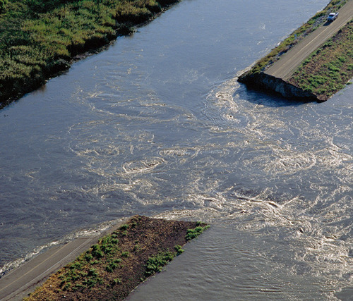
Levee breach, photo courtesy of DWR
Climate Change
Extreme weather associated with climate change may severely reduce SWP supplies available to Metropolitan in future years. Existing water quality and minimum flow regulations mean that during intense drought periods, very little SWP supplies may be delivered to Southern California.
Sea-Level Rise
Rising sea levels will not only put more pressure on the Delta’s dirt and peat levees; they also push seawater further into the Delta, impacting water quality, and threatening intake pumps that draw water out of the Delta and into the California Aqueduct, for delivery to cities and farms in the south. The levees are especially vulnerable as they sit only a few feet above sea level.
Soil Subsidence
In the 1850s, the Delta was transformed from a marsh into farmland, using levees to hold back water. This activity exposed peat soils, which are rapidly vaporizing, causing land levels to drop and turning the islands into bowls entirely dependent on the levees for preservation. As subsidence continues, water pressure on the levees increases, putting them at greater risk of collapse, which would draw seawater toward the Delta’s freshwater pathway.
Earthquakes
With several faults running through the region, the U.S. Geological Survey estimates a 72% percent chance of a magnitude 6.7 earthquake hitting the Bay Area in the next 30 years. This could cause widespread failures along the 1,100 miles of levees that surround Delta islands, allowing seawater to enter and render the freshwater that travels between the levees undrinkable for months, or even years.
Fishery Declines
Various endangered species call the Delta home. Regulators’ efforts to protect these species have largely focused on cutting back water exports from the SWP, although numerous scientific investigations have attributed the decline in the Delta’s ecosystem health to various causes.

Sacramento-San Joaquin Delta
The Proposed Delta Conveyance Project
Gov. Gavin Newsom's Delta Conveyance Project proposes to modernize the state's water infrastructure in the Delta to increase water supply reliability for 27 million Californians.
The proposed project is distinct from previous efforts to develop an alternative path to move water across the Delta region. Identified as the Bethany Reservoir alignment, the project would carry water from two new intakes on the Sacramento River in the north Delta and through a tunnel that nearly parallels Interstate 10 to the Bethany Reservoir situated at the start of the California Aqueduct.
The proposed project, with a capacity of 6,000 cubic feet per second, would allow for the capture of water supplies during particularly wet periods. Under dry and average conditions, state project supplies would continue to move through the Delta, as they currently do.
In December 2023, the California Department of Water Resources released its final Environmental Impact Report for the Delta Conveyance Project. Read Metropolitan's statement on the release of the final EIR.
Metropolitan’s board and water leaders across the state will use the state's Environmental Impact Report for the Delta Conveyance Project, along with additional information, such as the state’s benefit-cost analysis, to determine how to best invest our resources in response to a changing climate, while also supporting the state’s coequal goal to protect, restore and enhance the Delta ecosystem.
On May 16, 2024, the Department of Water Resources released a cost estimate and benefit-cost analysis. Read Metropolitan's statement.
So far, Metropolitan’s board has voted to support funding the district’s share of environmental planning and pre-construction costs, joining other State Water Project Contractors. The board’s most recent vote was in December 2020.
While the DCP is under consideration, Metropolitan has been meeting with diverse voices within the Delta - including NGO, tribal, academic and government agencies - to identify common interests and improve reliability in the Delta.
The Environmental Impact Report
Bethany Reservoir, photo courtesy of DWR
After launching the environmental review process in January 2020, the Draft EIR was released in July 2022 for public comment. The final report was released by the California Department of Water Resources in December 2023. This report evaluates and identifies potential environmental impacts of the proposed project and alternatives and will allow Metropolitan to conduct its own analyses and beginning in mid-2024 evaluate the potential costs and benefits of the project in support of our board’s decision-making process.
A Community Benefits Program Framework was included in the Final Environmental Impact Report, signaling DWR’s commitment to ensuring benefits for the Delta community and providing an opportunity for the public to comment on the concepts included in the framework.
With certification of the Final EIR, the Community Benefits Program will officially become part of the proposed Delta Conveyance Project under consideration by Metropolitan’s board and other water leaders across the state.
In the months ahead, DWR will negotiate permits in compliance with the California Endangered Species Act and federal Endangered Species Act, as well as a Change in Point of Diversion from the State Water Resources Control Board to ensure the new north Delta intakes would be operated to meet current laws, regulations and protections.
Sites Reservoir Project
Sites Reservoir is a proposed 1.5 million acre-foot off-stream reservoir in the Sacramento Valley that would capture stormwater flows from the Sacramento River after all other water rights and regulatory requirements are met, maximizing benefits to cities, agricultural communities and the environment. In Southern California, this translates to improved supply reliability in drought years, especially for our communities that are dependent on the State Water Project as well as reduced risk of depleting Southern California’s groundwater supplies.
Since 2017, Metropolitan has invested about $31 million into the planning, permitting and environmental review effort for Sites Reservoir. Any future investment would need to be considered by Metropolitan’s board.
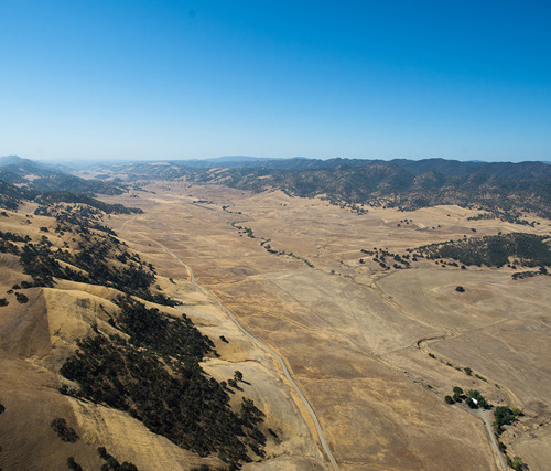
Proposed location of Sites Reservoir, photo courtesy of DWR
Resources
Lake Perris, photo courtesy of DWR

